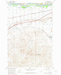
1967 Map of Nibbe
USGS Topo · Published 1980About this map
The Yellowstone River cuts across this Montana landscape, defining a corridor of heavy industry and transit north of the Yellowstone Co Big Horn Co boundary. The landmark Pompeys Pillar stands as a sentinel near the riverbanks, marking a site of deep historical significance long used by travelers. The era's irrigation infrastructure is well-defined by the Main Canal and Highline Canal, which transformed the arid terrain into productive land.
Find a feature on this map
21 named features on this map. Tap any name to fly to it.
Don’t see what you’re looking for? This feature index may not catch every label — zoom into the map to look around manually.
Map Details
Editions of this 1967 Nibbe Map
2 editions found

Other maps of this area

1893 · Huntley
USGS Topo · 1:125,000

1894 · Fort Custer
USGS Topo · 1:125,000

1954 · Billings
USGS Topo · 1:250,000

1954 · Hardin
USGS Topo · 1:250,000

1954 · Forsyth
USGS Topo · 1:250,000

1954 · Roundup
USGS Topo · 1:250,000

1957 · Hardin
USGS Topo · 1:250,000

1957 · Forsyth
USGS Topo · 1:250,000

1957 · Billings
USGS Topo · 1:250,000

1958 · Billings
USGS Topo · 1:250,000