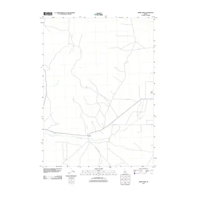
2010 Map of Nibbs Creek
USGS Topo · Published 2010About this map
Cassia Creek flows across the southern Idaho landscape of this 2010 survey, anchoring the local road and ranching networks. The settlement of Conant sits along the creek at the intersection of several rural routes, including the family-named Ward Sheep Ranch Rd and Sears Ln, illustrating the agricultural character of Cassia County. The drainage patterns of the high desert are clearly defined by numerous tributaries like Rice Creek, Blacksmith Creek, and Nibbs Creek, many of which are fed by isolated water sources such as Nibbs Spring and McClenden Spring. On the eastern edge of the quadrangle, the Malta Airport serves as a modern landmark in a region otherwise dominated by traditional ranching lands and grazing trails like Cattle Rd. This map provides a detailed view of the water rights and road networks essential to the area's rural economy.
Find a feature on this map
17 named features on this map. Tap any name to fly to it.
Don’t see what you’re looking for? This feature index may not catch every label — zoom into the map to look around manually.
Map Details
Editions of this 2010 Nibbs Creek Map
This is the sole edition of this map. No revisions or reprints were ever made.
Other maps of this area

1954 · Pocatello
USGS Topo · 1:250,000

1958 · Pocatello
USGS Topo · 1:250,000

1968 · Malta NE
USGS Topo · 1:24,000

1968 · Malta
USGS Topo · 1:24,000

1968 · Idahome
USGS Topo · 1:24,000

1968 · Elba
USGS Topo · 1:24,000

1968 · Kane Canyon
USGS Topo · 1:24,000

1968 · Nibbs Creek
USGS Topo · 1:24,000

1968 · Albion
USGS Topo · 1:24,000
1968 · Connor Ridge
USGS Topo · 1:24,000