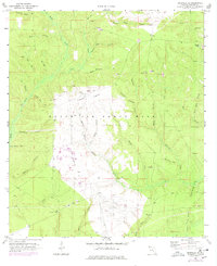
1970 Map of Niceville SE
USGS Topo · Published 1978About this map
Eglin Air Force Base dominates this Florida panhandle landscape, which was updated in 1976 to reflect the expansion of the military facility. The terrain is defined by a dense network of hydrologic features, including family-named watercourses such as Bully Horselot Br, Old Peg Branch, and Dogwood Head Br. These drainages feed into larger systems like Rocky Creek and Mullet Creek, while the presence of several Sandpits indicates local material extraction during the mid-20th century.
Find a feature on this map
47 named features on this map. Tap any name to fly to it.
Don’t see what you’re looking for? This feature index may not catch every label — zoom into the map to look around manually.
Map Details
Editions of this 1970 Niceville SE Map
3 editions found
Other maps of this area

1934 · Niceville
USGS Topo · 1:48,000

1935 · Villa Tasso
USGS Topo · 1:48,000

1935 · De Funiak Springs
USGS Topo · 1:48,000

1936 · Niceville
USGS Topo · 1:62,500

1936 · Point Washington
USGS Topo · 1:48,000

1938 · Villa Tasso
USGS Topo · 1:62,500

1938 · De Funiak Springs
USGS Topo · 1:62,500

1939 · Point Washington
USGS Topo · 1:62,500

1956 · Niceville
USGS Topo · 1:62,500

1956 · Villa Tasso
USGS Topo · 1:62,500