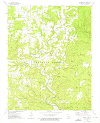
1973 Map of Nichols Knob
USGS Topo · Published 1976About this map
North Fork Bryant Creek carves a deep, winding path through this portion of the Mark Twain National Forest in the early 1970s. The settlement of Topaz sits at a critical bend in the river, supported by the nearby Topaz Spring. The landscape is defined by a dense network of named hollows, such as Brushy Mill Hollow, Sam Wood Hollow, and Hell Hole Hollow, which drain the high ridges into the creek system. This topography dictated a scattered settlement pattern, where community life centered around small country churches and family landmarks.
Find a feature on this map
48 named features on this map. Tap any name to fly to it.
Don’t see what you’re looking for? This feature index may not catch every label — zoom into the map to look around manually.
Map Details
Editions of this 1973 Nichols Knob Map
This is the sole edition of this map. No revisions or reprints were ever made.
Other maps of this area

1937 · Buckhart
USGS Topo · 1:48,000

1939 · Topaz
USGS Topo · 1:62,500

1941 · Topaz
USGS Topo · 1:62,500

1943 · Buckhart
USGS Topo · 1:62,500

1945 · Harrison
USGS Topo · 1:250,000

1945 · Buckhart
USGS Topo · 1:62,500

1949 · Harrison
USGS Topo · 1:250,000

1950 · Cabool SW
USGS Topo · 1:24,000

1951 · Mountain Grove South
USGS Topo · 1:24,000

1951 · Cabool SE
USGS Topo · 1:24,000