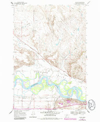
1968 Map of Nichols
USGS Topo · Published 1986About this map
The Yellowstone River dominates this landscape, its winding channels and braided islands carving through the broad plains of Hammond Valley and Howard Valley. During the mid-to-late 20th century, this region of Rosebud County served as a vital transportation corridor, where the Burlington Northern railroad lines followed the southern bank of the river. The small settlement of Nichols sits at the junction of these rails and the mouth of Armells Creek, representing a typical river-and-rail outpost of the era.
Find a feature on this map
35 named features on this map. Tap any name to fly to it.
Don’t see what you’re looking for? This feature index may not catch every label — zoom into the map to look around manually.
Map Details
Editions of this 1968 Nichols Map
2 editions found
Other maps of this area

1954 · Forsyth
USGS Topo · 1:250,000

1957 · Forsyth
USGS Topo · 1:250,000

1958 · Forsyth
USGS Topo · 1:250,000

1968 · Donleys Reservoir
USGS Topo · 1:24,000

1968 · Nichols
USGS Topo · 1:24,000

1968 · Forsyth
USGS Topo · 1:24,000

1968 · Finch NE
USGS Topo · 1:24,000

1968 · Black Coulee
USGS Topo · 1:24,000

1968 · Finch
USGS Topo · 1:24,000

1971 · Griffin Coulee NE
USGS Topo · 1:24,000