
1919 Map of Nicholville
USGS Topo · Published 1958About this map
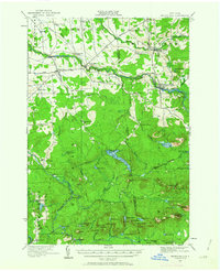
Nicholville sits at the junction of the St Regis River and its various tributaries, serving as a focal point for this northern Adirondack border region. The landscape is defined by the transition from the cleared farmlands of St Lawrence Co and Franklin Co into the dense woods and peaks of the Adirondack Park. A high density of rural schools, such as the Merchant Street School and Lake Ozonia School, illustrates the dispersed nature of the population in the early twentieth century. Moving south, the terrain rises toward Eagle Mtn and Blue Mtn, where the economy shifted from agriculture to timber and recreation. Local infrastructure like the Brooklyn Division road and Cooperage Road provide evidence of the logging and barrel-making industries that once thrived alongside water features like Lake Ozonia and St Regis Falls.
Find a feature on this map
84 named features on this map. Tap any name to fly to it.
Don’t see what you’re looking for? This feature index may not catch every label — zoom into the map to look around manually.
Map Details
Editions of this 1919 Nicholville Map
2 editions found
Other maps of this area

1905 · Saint Regis
USGS Topo · 1:62,500

1906 · Massena
USGS Topo · 1:62,500

1907 · Massena
USGS Topo · 1:62,500

1908 · Potsdam
USGS Topo · 1:62,500

1915 · Malone
USGS Topo · 1:62,500

1915 · Moira
USGS Topo · 1:62,500

1917 · Malone
USGS Topo · 1:62,500

1917 · Moira
USGS Topo · 1:62,500

1920 · Childwold
USGS Topo · 1:62,500

1921 · Childwold
USGS Topo · 1:48,000