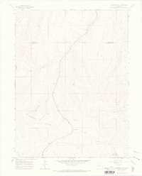
1966 Map of Ninemile Gap
USGS Topo · Published 1969About this map
The Danforth Hills define this high-altitude landscape along the border of Moffat and Rio Blanco counties in the mid-1960s. This survey records an era of energy extraction and remote livestock management, characterized by numerous Oil Wells, a Drift Hole, and several gravel pits scattered throughout the drainage systems. The Taylor Mine and other unnamed mining sites suggest a reliance on the area's mineral resources, while the presence of the Lunney Reservoir indicates the critical importance of water management in this arid terrain. A network of Jeep Trails and Pack Trails provide the primary means of navigation through the gap, connecting isolated work sites to more established routes. Notable geographic landmarks like Ninemile Gap and Hole-in-the-Wall Gulch serve as natural passage points through the elevated ridges, while Good Spring Creek and Curtis Creek carve distinct paths through the hills.
Find a feature on this map
24 named features on this map. Tap any name to fly to it.
Don’t see what you’re looking for? This feature index may not catch every label — zoom into the map to look around manually.
Map Details
Editions of this 1966 Ninemile Gap Map
4 editions found
Other maps of this area

1910 · Danforth Hills
USGS Topo · 1:125,000

1912 · Meeker
USGS Topo · 1:62,500

1912 · Axial
USGS Topo · 1:62,500

1914 · Meeker
USGS Topo · 1:62,500

1914 · Axial
USGS Topo · 1:62,500

1915 · Monument Butte
USGS Topo · 1:62,500

1954 · Craig
USGS Topo · 1:250,000

1957 · Craig
USGS Topo · 1:250,000

1958 · Craig
USGS Topo · 1:250,000

1960 · Craig
USGS Topo · 1:250,000