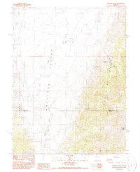
1990 Map of Ninemile Peak
USGS Topo · Published 1990About this map
The Antelope Range and the high desert of the Antelope Valley define this Central Nevada landscape at the intersection of Eureka and Nye counties. This 1990 provisional map documents a transition from the alluvial fans of the valley floor into the steep, rising elevations of the range, culminating at Ninemile Peak. The presence of small-scale mining activity is evident through numerous scattered Prospect and Prospects labels, alongside a Gravel Pit in the northwest. Water resources are critically mapped in this arid environment, showing essential seasonal drainages like White Rock Creek and Meadow Creek, as well as permanent water sources such as Water Canyon Spring and Mountain Lion Spring. A portion of the Toiyabe National Forest occupies the western edge, indicating federal land management in this cattle-grazing and mineral-exploration territory.
Find a feature on this map
17 named features on this map. Tap any name to fly to it.
Don’t see what you’re looking for? This feature index may not catch every label — zoom into the map to look around manually.
Map Details
Editions of this 1990 Ninemile Peak Map
This is the sole edition of this map. No revisions or reprints were ever made.
Other maps of this area

1926 · Roberts Mountains
USGS Topo · 1:250,000

1929 · Roberts Mountains
USGS Topo · 1:250,000

1955 · Millett
USGS Topo · 1:250,000

1956 · Bellevue Peak
USGS Topo · 1:62,500

1956 · Cockalorum Wash
USGS Topo · 1:62,500

1956 · Horse Heaven Mtn
USGS Topo · 1:62,500

1956 · Antelope Peak
USGS Topo · 1:62,500

1959 · Millett
USGS Topo · 1:250,000

1978 · Summit Mountain
USGS Topo · 1:100,000
1989 · Ninemile Peak
USGS Topo · 1:24,000