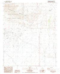
1988 Map of Ninemile Wash
USGS Topo · Published 1988About this map
The Chocolate Mountains dominate this California desert landscape, defined by a heavy industrial and military presence in the late twentieth century. Large portions of the terrain are designated as part of the Naval Aerial Gunnery Range, reflecting the area's role in mid-century defense operations. The map reveals an intensive history of resource extraction, centered around major operations like the Mesquite Mine and smaller ventures such as the Rainbow Mine, Vista Mine, and the Old Channel Mine Shaft. The drainage of Ninemile Wash cuts through the arid basins between the peaks of Black Mountain and the main range, where numerous unnamed prospects indicate the persistent search for minerals across these public and reservation lands. A complex network of 4wd tracks and a prominent Trans Line provide the only infrastructure in this sparsely settled mining corridor.
Find a feature on this map
18 named features on this map. Tap any name to fly to it.
Don’t see what you’re looking for? This feature index may not catch every label — zoom into the map to look around manually.
Map Details
Editions of this 1988 Ninemile Wash Map
2 editions found
Other maps of this area

1903 · Yuma
USGS Topo · 1:125,000

1905 · Yuma
USGS Topo · 1:125,000

1907 · Holtville
USGS Topo · 1:125,000

1942 · El Centro
USGS Topo · 1:250,000

1942 · Yuma
USGS Topo · 1:250,000

1942 · Blythe
USGS Topo · 1:250,000

1953 · Quartz Peak
USGS Topo · 1:62,500

1953 · Ogilby
USGS Topo · 1:62,500

1953 · Acolita
USGS Topo · 1:62,500

1954 · El Centro
USGS Topo · 1:250,000