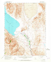
1957 Map of Nixon
USGS Topo · Published 1965About this map
The Pyramid Lake Indian Reservation Boundary encompasses a stark desert landscape where the Truckee River flows into the terminal basin of Pyramid Lake. This mid-century survey captures the settlement of Nixon at the river's bend, serving as a hub for the reservation and a key point along the Southern Pacific railroad line. The map highlights the significant elevation of the water at 3,802 feet as of September 1957, while the neighboring basin of Winnemucca Lake sits to the northeast. High peaks like Virginia Peak and Pah Rah Mtn dominate the western horizon, overlooking a network of springs and canyons such as Rodeo Springs and Big Mouth Canyon. Mining activity is evident through scattered prospects in the Truckee Range, while the Anaho Island Nat Wildlife Refuge provides a protected sanctuary within the lake's blue expanse.
Find a feature on this map
45 named features on this map. Tap any name to fly to it.
Don’t see what you’re looking for? This feature index may not catch every label — zoom into the map to look around manually.
Map Details
Editions of this 1957 Nixon Map
3 editions found

Other maps of this area

1886 · Granite Range
USGS Topo · 1:250,000

1890 · Wadsworth
USGS Topo · 1:125,000

1891 · Reno
USGS Topo · 1:125,000

1892 · Wadsworth
USGS Topo · 1:125,000

1893 · Reno
USGS Topo · 1:125,000

1894 · Granite Range
USGS Topo · 1:250,000

1894 · Wadsworth
USGS Topo · 1:125,000

1955 · Lovelock
USGS Topo · 1:250,000

1957 · Sutcliffe
USGS Topo · 1:62,500

1957 · Fireball Ridge
USGS Topo · 1:62,500