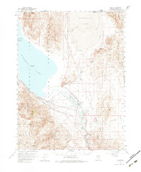
1957 Map of Nixon
USGS Topo · Published 1983About this map
The Pyramid Lake Indian Reservation dominates this mid-century landscape, where the waters of Pyramid Lake and Winnemucca Lake are separated by the high ridges of the Lake Range. The settlement of Nixon serves as a central hub near the southern bend of the Truckee River, located at the junction of rail and river transit. The presence of the Southern Pacific railroad line indicates the corridor's role in regional logistics, skirting the base of the Pah Rah Range and passing through the rugged interior canyons. Ecological and geological interests are marked by the Anaho Island Nat Wildlife Refuge and the prominent Marble Bluff. Scattered mining prospects in the Truckee Range and Nightingale Mts suggest a history of mineral exploration throughout these arid Great Basin highlands.
Find a feature on this map
28 named features on this map. Tap any name to fly to it.
Don’t see what you’re looking for? This feature index may not catch every label — zoom into the map to look around manually.
Map Details
Editions of this 1957 Nixon Map
3 editions found

Other maps of this area

1886 · Granite Range
USGS Topo · 1:250,000

1890 · Wadsworth
USGS Topo · 1:125,000

1891 · Reno
USGS Topo · 1:125,000

1892 · Wadsworth
USGS Topo · 1:125,000

1893 · Reno
USGS Topo · 1:125,000

1894 · Granite Range
USGS Topo · 1:250,000

1894 · Wadsworth
USGS Topo · 1:125,000

1955 · Lovelock
USGS Topo · 1:250,000

1957 · Sutcliffe
USGS Topo · 1:62,500

1957 · Fireball Ridge
USGS Topo · 1:62,500