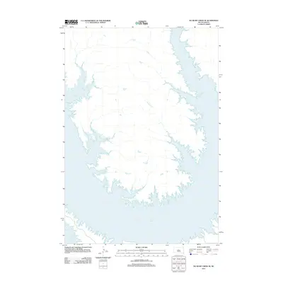
2012 Map of No Heart Creek SE
USGS Topo · Published 2012About this map
Lake Oahe dominates the landscape of this region, its expansive waters and intricate, branched shoreline filling the southern and eastern portions of the map. This reservoir, created by the damming of the Missouri River, defines the modern geography of this part of South Dakota, covering former river bottomlands and altering the drainage patterns of the surrounding plains. To the north, the land rises into a series of drainages, most notably Fairbanks Cr and Splits Cr, which carve through the terrain before emptying into the lake's inlets. The map reveals a sparsely developed area where the natural topography is the primary feature, illustrating how the massive water project has reshaped the environment and created a complex network of bays and points along the Missouri River valley.
Find a feature on this map
3 named features on this map. Tap any name to fly to it.
Don’t see what you’re looking for? This feature index may not catch every label — zoom into the map to look around manually.
Map Details
Editions of this 2012 No Heart Creek SE Map
This is the sole edition of this map. No revisions or reprints were ever made.
Other maps of this area

1954 · Pierre
USGS Topo · 1:250,000

1958 · Pierre
USGS Topo · 1:250,000

1965 · Artichoke Butte SW
USGS Topo · 1:24,000

1965 · Okobojo
USGS Topo · 1:24,000

1969 · No Heart Creek SE
USGS Topo · 1:24,000

1969 · Artichoke Butte NW
USGS Topo · 1:24,000

1969 · No Heart Creek SW
USGS Topo · 1:24,000

1973 · Iron Post Buttes
USGS Topo · 1:24,000
1973 · Mail Shack Creek
USGS Topo · 1:24,000
1981 · No Heart Creek NE
USGS Topo · 1:24,000