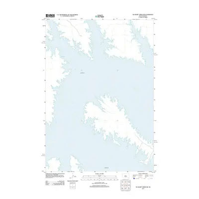
2012 Map of No Heart Creek SW
USGS Topo · Published 2012About this map
Lake Oahe dominates the Missouri River valley in this 2012 survey, its expansive waters filling the intricate, winding shoreline of the central South Dakota landscape. The map highlights the prominent Little Bend, a significant topographical feature where the river corridor takes a sharp, sweeping turn. The terrain is characterized by the complex dendritic drainage patterns that feed into the reservoir, illustrating the dramatic change in the regional geography following the mid-century damming of the Missouri. Sparse development near the shoreline is marked by occasional local roads and a boat ramp, providing access to the vast waterway that defines this portion of Dewey County.
Find a feature on this map
2 named features on this map. Tap any name to fly to it.
Don’t see what you’re looking for? This feature index may not catch every label — zoom into the map to look around manually.
Map Details
Editions of this 2012 No Heart Creek SW Map
This is the sole edition of this map. No revisions or reprints were ever made.
Other maps of this area

1954 · Pierre
USGS Topo · 1:250,000

1958 · Pierre
USGS Topo · 1:250,000

1969 · Rousseau Creek
USGS Topo · 1:24,000

1969 · No Heart Creek SE
USGS Topo · 1:24,000

1969 · No Heart Creek SW
USGS Topo · 1:24,000

1973 · Iron Post Buttes
USGS Topo · 1:24,000
1973 · Mail Shack Creek
USGS Topo · 1:24,000

1981 · Charlie Creek
USGS Topo · 1:24,000
1981 · No Heart Creek NE
USGS Topo · 1:24,000
1981 · No Heart Creek
USGS Topo · 1:24,000