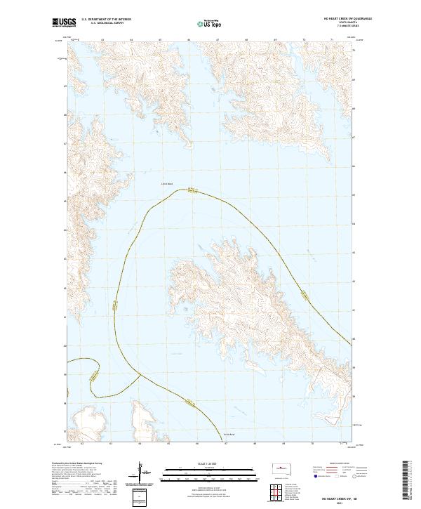
2021 Map of No Heart Creek SW
USGS Topo · Published 2021About this map
Little Bend defines this portion of the Missouri River, where the water transitions into the expansive waters of Lake Oahe. This geography marks a critical point of convergence between Dewey, Sully, and Stanley counties. The landscape is dominated by the flooded river valley, which has transformed the traditional riverbank into a complex shoreline. The map illustrates the contemporary boundaries of the Public Land Survey System, including T116N R82W and T115N R82W, superimposed over the modern reservoir. The intricate contour lines along the shores of the bend reveal the dramatic elevation changes that characterize the Missouri River breaks, providing a clear visualization of the terrain submerged or reshaped by the Missouri River's mid-century damming projects.
Find a feature on this map
14 named features on this map. Tap any name to fly to it.
Don’t see what you’re looking for? This feature index may not catch every label — zoom into the map to look around manually.
Map Details
Editions of this 2021 No Heart Creek SW Map
This is the sole edition of this map. No revisions or reprints were ever made.
Other maps of this area

1954 · Pierre
USGS Topo · 1:250,000

1958 · Pierre
USGS Topo · 1:250,000

1969 · Rousseau Creek
USGS Topo · 1:24,000

1969 · No Heart Creek SE
USGS Topo · 1:24,000

1969 · No Heart Creek SW
USGS Topo · 1:24,000

1973 · Iron Post Buttes
USGS Topo · 1:24,000
1973 · Mail Shack Creek
USGS Topo · 1:24,000

1981 · Charlie Creek
USGS Topo · 1:24,000
1981 · No Heart Creek NE
USGS Topo · 1:24,000
1981 · No Heart Creek
USGS Topo · 1:24,000