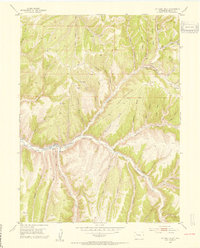
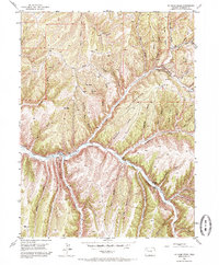
1952 Map of No Name Ridge
USGS Topo · Published 1954About this map
Piceance Creek carves a central valley through this high-desert landscape in Rio Blanco County, anchoring a series of small agricultural outposts in the early 1950s. The map illustrates a ranching economy dependent on the water of the creek and several Spring sources, with Gubline Ranch, Jones Ranch, and Robinson Ranch situated along the valley floor. A complex system of irrigation is evident, including a notable Ditch running parallel to the creek to support these isolated holdings. Beyond the irrigated bottoms, the terrain rises sharply into prominent features like No Name Ridge and Fourteenmile Ridge. Industrial footprints are beginning to appear in the backcountry, marked by several Shale Prospects and scattered Gas Well locations, signaling the early development of the region's energy resources. Access across the drainage-heavy terrain is provided by the Thirteenmile Road and various tracks like the Goat Trail Ridge.
Find a feature on this map
58 named features on this map. Tap any name to fly to it.
Don’t see what you’re looking for? This feature index may not catch every label — zoom into the map to look around manually.
Map Details
Editions of this 1952 No Name Ridge Map
6 editions found
Other maps of this area

1906 · Grand Hogback
USGS Topo · 1:125,000

1910 · Grand Hogback
USGS Topo · 1:125,000

1925 · Parachute Creek
USGS Topo · 1:62,500

1927 · Parachute Creek
USGS Topo · 1:62,500

1952 · Rio Blanco
USGS Topo · 1:24,000

1952 · Jessup Gulch
USGS Topo · 1:24,000

1952 · Greasewood Gulch
USGS Topo · 1:24,000

1952 · No Name Ridge
USGS Topo · 1:24,000

1952 · Segar Mountain
USGS Topo · 1:24,000

1956 · Grand Junction
USGS Topo · 1:250,000