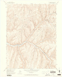
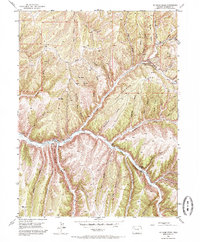
1952 Map of No Name Ridge
USGS Topo · Published 1964About this map
Piceance Creek meanders through this high-plateau landscape of Rio Blanco County, anchoring a series of small agricultural outposts in the early 1950s. The map illustrates a network of early ranching and resource extraction, where Gubline Ranch and Robinson Ranch sit nestled in the valley floor. Evidence of the region’s energy potential appears in the form of several scattered Gas Well sites and Shale Prospect locations on the northern ridges. The terrain is deeply incised by countless drainage systems, from the prominent No Name Ridge to the steep walls of Thirteenmile Canyon. Long-established routes like the Fourteenmile Trail traverse the high ground between Rough Ridge and Goat Trail Ridge, connecting the isolated valley settlements with the higher elevations of Bald Knob.
Find a feature on this map
47 named features on this map. Tap any name to fly to it.
Don’t see what you’re looking for? This feature index may not catch every label — zoom into the map to look around manually.
Map Details
Editions of this 1952 No Name Ridge Map
6 editions found
Other maps of this area

1906 · Grand Hogback
USGS Topo · 1:125,000

1910 · Grand Hogback
USGS Topo · 1:125,000

1925 · Parachute Creek
USGS Topo · 1:62,500

1927 · Parachute Creek
USGS Topo · 1:62,500

1952 · Rio Blanco
USGS Topo · 1:24,000

1952 · Jessup Gulch
USGS Topo · 1:24,000

1952 · Greasewood Gulch
USGS Topo · 1:24,000

1952 · No Name Ridge
USGS Topo · 1:24,000

1952 · Segar Mountain
USGS Topo · 1:24,000

1956 · Grand Junction
USGS Topo · 1:250,000