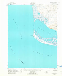
1952 Map of Noatak A-4
USGS Topo · Published 1964About this map
Cape Krusenstern anchors this coastal study, marking the point where the Chukchi Sea meets Kotzebue Sound. The landscape is dominated by the massive Krusenstern Lagoon, separated from the open Arctic Ocean by a narrow barrier of Sand and Gravel. This shoreline features a lone Landing Strip and a Shelter Cabin, indicating the area's importance as a remote waypoint for coastal travel. Inland, the topography rises toward Eigaloruk Mtn and Ingitkalik Mtn, while the complex hydrology of Tulilik Lake and the Evelukpalik River drains into the lagoon system. Traces of human presence appear at the Tikizat (site) and the settlement of Talikoot (Aban'd), offering clues for researchers tracking indigenous land use and abandoned Arctic habitations.
Find a feature on this map
19 named features on this map. Tap any name to fly to it.
Don’t see what you’re looking for? This feature index may not catch every label — zoom into the map to look around manually.
Map Details
Editions of this 1952 Noatak A-4 Map
2 editions found
Other maps of this area

1951 · Noatak
USGS Topo · 1:250,000

1951 · Kotzebue
USGS Topo · 1:250,000

1952 · Noatak A-3
USGS Topo · 1:63,360
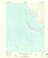
1952 · Noatak A-4
USGS Topo · 1:63,360

1955 · Noatak
USGS Topo · 1:250,000

1955 · Noatak B-3
USGS Topo · 1:63,360

1955 · Noatak B-4
USGS Topo · 1:63,360

1958 · Kotzebue
USGS Topo · 1:250,000

1964 · Noatak
USGS Topo · 1:250,000

1964 · Kotzebue
USGS Topo · 1:250,000