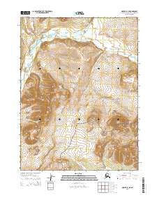
2015 Map of Noatak B-1 NE
USGS Topo · Published 2015About this map
Noatak National Preserve encompasses the vast majority of this landscape in the Northwest Arctic, where the terrain is defined by high-elevation ridgelines and braided drainage systems. The Agashashok River cuts through the northern portion of the sheet, winding between steep slopes in an area devoid of permanent modern settlements or established roads. This survey illustrates the protected status of the western Brooks Range, capturing a wilderness where the land is primarily managed as a federal preserve. The map focuses on the complex topography and natural hydrology of the Arctic interior, providing a detailed record of elevations and water courses within the Noatak National Preserve.
Find a feature on this map
6 named features on this map. Tap any name to fly to it.
Don’t see what you’re looking for? This feature index may not catch every label — zoom into the map to look around manually.
Map Details
Editions of this 2015 Noatak B-1 NE Map
This is the sole edition of this map. No revisions or reprints were ever made.
Other maps of this area

1951 · Baird Mountains
USGS Topo · 1:250,000

1951 · Noatak
USGS Topo · 1:250,000

1955 · Noatak
USGS Topo · 1:250,000

1955 · Noatak C-1
USGS Topo · 1:63,360
1955 · Baird Mountains B-6
USGS Topo · 1:63,360
1955 · Baird Mountains C-6
USGS Topo · 1:63,360
1955 · Noatak B-1
USGS Topo · 1:63,360

1956 · Baird Mountains
USGS Topo · 1:250,000

1964 · Noatak
USGS Topo · 1:250,000

1965 · Baird Mountains
USGS Topo · 1:250,000