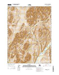
2015 Map of Noatak C-1 SE
USGS Topo · Published 2015About this map
Noatak National Preserve defines the vast majority of this landscape in the Northwest Arctic Borough. The terrain is characterized by the winding path of the Agashashok River, which cuts through the southeastern corner of the quadrangle. This 2015 survey illustrates a wilderness nearly untouched by permanent infrastructure, focused instead on the natural topography of the Brooks Range foothills. The map relies on precise elevation data from the National Elevation Dataset and imagery from Spot to document the drainage patterns and ridgelines that shape this protected Arctic environment. It is a portrait of a landscape where the absence of roads and human settlements emphasizes the scale of the river system and the surrounding preserve.
Find a feature on this map
8 named features on this map. Tap any name to fly to it.
Don’t see what you’re looking for? This feature index may not catch every label — zoom into the map to look around manually.
Map Details
Editions of this 2015 Noatak C-1 SE Map
This is the sole edition of this map. No revisions or reprints were ever made.
Other maps of this area

1951 · Baird Mountains
USGS Topo · 1:250,000

1951 · Noatak
USGS Topo · 1:250,000

1955 · Noatak
USGS Topo · 1:250,000

1955 · Noatak C-1
USGS Topo · 1:63,360
1955 · Baird Mountains B-6
USGS Topo · 1:63,360
1955 · Baird Mountains C-6
USGS Topo · 1:63,360
1955 · Noatak B-1
USGS Topo · 1:63,360

1956 · Baird Mountains
USGS Topo · 1:250,000

1964 · Noatak
USGS Topo · 1:250,000

1965 · Baird Mountains
USGS Topo · 1:250,000