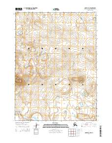
2014 Map of Noatak D-4 NW
USGS Topo · Published 2014About this map
Mount Jarvis dominates the southwestern corner of this survey, standing as a prominent landmark in the Arctic landscape of the Northwest Arctic Borough. The terrain is defined by a rhythmic series of low elevations and drainage patterns that span the townships of t30n r23w, t30n r22w, t29n r23w, and t29n r22w. This area is characterized by its isolation and the intricate network of natural contours, showing the land as it remained in the early 21st century. The map provides a detailed look at the public land survey system divisions in a region where few permanent structures or man-made features are recorded, emphasizing the natural topography and the prominence of name-bearing features like the mountain peak.
Find a feature on this map
5 named features on this map. Tap any name to fly to it.
Don’t see what you’re looking for? This feature index may not catch every label — zoom into the map to look around manually.
Map Details
Editions of this 2014 Noatak D-4 NW Map
This is the sole edition of this map. No revisions or reprints were ever made.
Other maps of this area

1951 · De Long Mountains
USGS Topo · 1:250,000

1951 · Noatak
USGS Topo · 1:250,000

1955 · Noatak
USGS Topo · 1:250,000

1955 · De Long Mountains
USGS Topo · 1:250,000

1955 · Noatak D-4
USGS Topo · 1:63,360

1955 · De Long Mountains A-3
USGS Topo · 1:63,360

1955 · De Long Mountains A-4
USGS Topo · 1:63,360
1955 · Noatak D-5
USGS Topo · 1:63,360

1964 · Noatak
USGS Topo · 1:250,000

1965 · De Long Mountains
USGS Topo · 1:250,000