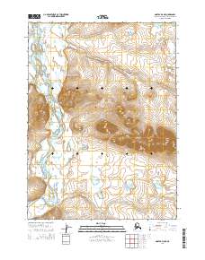
2014 Map of Noatak D-5 NE
USGS Topo · Published 2014About this map
The Kivalina River carves a serpentine path through this Arctic landscape, defining the local geography as it moves past Tulurak and through the broad Kunguyuluk Bend. The terrain is dominated by the high elevations of the Kisimilat Mountains, including the prominent peak of Mount Jarvis in the eastern portion of the quadrangle. These mountains are separated from northern ridges by the distinct Kitingirak Gap, a topographical feature that likely influenced traditional movement through the river valley.
Find a feature on this map
14 named features on this map. Tap any name to fly to it.
Don’t see what you’re looking for? This feature index may not catch every label — zoom into the map to look around manually.
Map Details
Editions of this 2014 Noatak D-5 NE Map
This is the sole edition of this map. No revisions or reprints were ever made.
Other maps of this area

1951 · De Long Mountains
USGS Topo · 1:250,000

1951 · Noatak
USGS Topo · 1:250,000

1955 · Noatak
USGS Topo · 1:250,000

1955 · De Long Mountains
USGS Topo · 1:250,000

1955 · Noatak D-4
USGS Topo · 1:63,360

1955 · De Long Mountains A-4
USGS Topo · 1:63,360
1955 · Noatak D-5
USGS Topo · 1:63,360

1964 · Noatak
USGS Topo · 1:250,000

1965 · De Long Mountains
USGS Topo · 1:250,000
2014 · Noatak D-4 SW
USGS Topo · 1:25,000