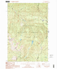
1989 Map of Noble Knob
USGS Topo · Published 1989About this map
The Snoqualmie National Forest and Norse Peak Wilderness dominate this high-altitude landscape where the headwaters of the Greenwater River and Little Naches River converge. This survey shows the area's intricate network of peaks and passes, including the historically significant Naches Pass and the prominent Noble Knob. The presence of the Green River Watershed and its strict boundaries reflect the vital role this terrain plays in the region's water management. Small outposts such as Camp Urich and Government Meadow are situated among the high ridges, providing a glimpse into the seasonal use of these subalpine meadows. This study documents a wilderness managed for both recreation and resource protection, preserved through features like Echo Lake and the Corral Pass Campground.
Find a feature on this map
41 named features on this map. Tap any name to fly to it.
Don’t see what you’re looking for? This feature index may not catch every label — zoom into the map to look around manually.
Map Details
Editions of this 1989 Noble Knob Map
2 editions found
Other maps of this area

1901 · Snoqualmie Pass
USGS Topo · 1:125,000

1902 · Mount Aix
USGS Topo · 1:125,000

1903 · Snoqualmie
USGS Topo · 1:125,000

1904 · Mt Aix
USGS Topo · 1:125,000

1913 · Cedar Lake
USGS Topo · 1:125,000

1924 · Mt Rainier
USGS Topo · 1:96,000

1928 · Mt Rainier
USGS Topo · 1:125,000

1950 · Yakima
USGS Topo · 1:250,000

1956 · Greenwater
USGS Topo · 1:62,500

1957 · Wenatchee
USGS Topo · 1:250,000