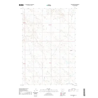
2020 Map of Noble Reservoir
USGS Topo · Published 2020About this map
Steamboat Butte rises above the drainage networks of Custer County, defining the local terrain in this section of eastern Montana. The landscape is primarily shaped by a dense system of intermittent waterways, including Muster Cr, Sand Cr, and Tree Cr, which flow through the dissected plains toward Sunday Creek at the southern edge. Human activity is marked by rural thoroughfares like Caprock Rd and Kinsey Rd, serving the scattered agricultural interests of the region. A notable point of water storage, Hall Reservoir, sits in the southeastern quadrant, reflecting the importance of water management in this arid environment. The map provides a clear look at the township and range survey lines, such as t10n r47e, which organize the remote territory into its jurisdictional blocks.
Find a feature on this map
15 named features on this map. Tap any name to fly to it.
Don’t see what you’re looking for? This feature index may not catch every label — zoom into the map to look around manually.
Map Details
Editions of this 2020 Noble Reservoir Map
This is the sole edition of this map. No revisions or reprints were ever made.
Other maps of this area

1953 · Miles City
USGS Topo · 1:250,000

1957 · Miles City
USGS Topo · 1:250,000

1958 · Miles City
USGS Topo · 1:250,000

1968 · Big Hill
USGS Topo · 1:24,000

1968 · Miles City
USGS Topo · 1:24,000

1969 · Horse Creek Hill
USGS Topo · 1:24,000

1969 · Noble Reservoir
USGS Topo · 1:24,000
1969 · Deadman Creek
USGS Topo · 1:24,000
1969 · Coal Bank Spring
USGS Topo · 1:24,000

1969 · Kinsey
USGS Topo · 1:24,000