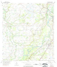
1956 Map of Nocatee
USGS Topo · Published 1975About this map
The Peace River meanders through DeSoto County, defining a landscape shaped by both water and rail transportation during the mid-20th century. The settlement of Nocatee serves as a local hub, situated where the Atlantic Coast Line Railroad and Seaboard Coast Line Railroad intersect. This junction, combined with the presence of an Old Railroad Grade to the west, illustrates the evolution of Florida's freight and passenger networks. To the north and west, the terrain is dotted with small bodies of water like Bee Gum Lake and Johnson Lake, alongside tributaries such as Joshua Creek and Horse Creek. Rural life is anchored by local landmarks including Mt Efen Ch and the Owens Cem, providing specific points of interest for genealogists tracing family histories in the orange groves and flatwoods of south-central Florida.
Find a feature on this map
15 named features on this map. Tap any name to fly to it.
Don’t see what you’re looking for? This feature index may not catch every label — zoom into the map to look around manually.
Map Details
Editions of this 1956 Nocatee Map
3 editions found
Other maps of this area

1956 · Gardner
USGS Topo · 1:24,000

1956 · Arcadia SE
USGS Topo · 1:24,000

1956 · Edgeville
USGS Topo · 1:24,000

1956 · Murdock SE
USGS Topo · 1:24,000

1956 · Murdock NE
USGS Topo · 1:24,000

1956 · Limestone
USGS Topo · 1:24,000

1956 · Ft. Ogden
USGS Topo · 1:24,000

1956 · Nocatee
USGS Topo · 1:24,000

1956 · Tampa
USGS Topo · 1:250,000

1956 · Fort Pierce
USGS Topo · 1:250,000