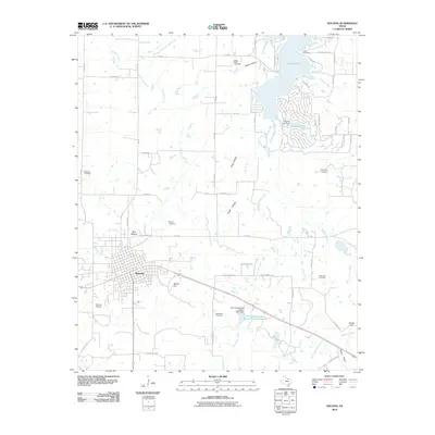
2010 Map of Nocona
USGS Topo · Published 2010About this map
Nocona serves as the focal point of this North Texas study, showcasing the town's grid and its proximity to the rising waters of Lake Nocona to the northeast. The landscape is defined by the drainage basins of Panther Creek and Greenbrier Creek, punctuated by prominent elevations such as Blue Mound and Benton Hill. A legacy of early settlement is clearly visible through the numerous family and community burial grounds scattered across the countryside, including Molsbee Cemetery, Robinson Cemetery, and Benton Cemetery. Water management is a significant theme of the era, illustrated by infrastructure such as the Leisure Lake Dam and the Soil Conservation Service Site 9 Reservoir, which reflect mid-century efforts to control local watersheds and create recreational spaces like Leisure Lake.
Find a feature on this map
70 named features on this map. Tap any name to fly to it.
Don’t see what you’re looking for? This feature index may not catch every label — zoom into the map to look around manually.
Map Details
Editions of this 2010 Nocona Map
This is the sole edition of this map. No revisions or reprints were ever made.
Other maps of this area

1905 · Montague
USGS Topo · 1:125,000

1954 · Sherman
USGS Topo · 1:250,000

1958 · Sherman
USGS Topo · 1:250,000

1960 · Buzzard Roost Knob
USGS Topo · 1:24,000

1961 · Saint Jo
USGS Topo · 1:24,000

1961 · Montague
USGS Topo · 1:24,000
1968 · Bonita
USGS Topo · 1:24,000
1968 · Spanish Fort
USGS Topo · 1:24,000

1968 · Nocona
USGS Topo · 1:24,000

1968 · Fleetwood
USGS Topo · 1:24,000