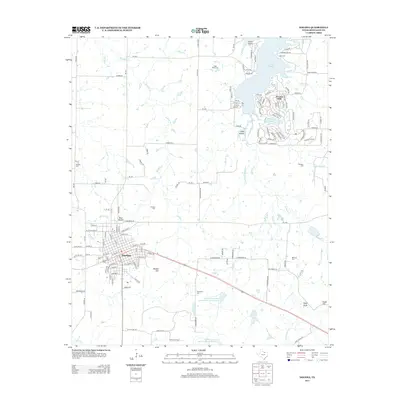
2013 Map of Nocona
USGS Topo · Published 2013About this map
Nocona serves as the primary hub in this northern Texas landscape, where the town’s grid transitions into the sprawling recreational developments around Lake Nocona. The 2013 survey illustrates the distinct contrast between the traditional settlement of Blue Mound and the modern residential patterns of Nocona Hills and Leisure Lake to the north. This area is a significant resource for genealogists, as it preserves the locations of numerous family and community burial grounds, including Keck Cem, Eagle Point Cem, and Molsbee Cem. The terrain is defined by its water systems, from the drainage of Panther Cr and Dripping Springs Cr to the massive Soil Conservation Service Site 9 Reservoir. High points like Benton Hill and Eagle Point overlook a countryside marked by the evolution of land management and rural infrastructure in Montague County.
Find a feature on this map
150 named features on this map. Tap any name to fly to it.
Don’t see what you’re looking for? This feature index may not catch every label — zoom into the map to look around manually.
Map Details
Editions of this 2013 Nocona Map
This is the sole edition of this map. No revisions or reprints were ever made.
Other maps of this area

1905 · Montague
USGS Topo · 1:125,000

1954 · Sherman
USGS Topo · 1:250,000

1958 · Sherman
USGS Topo · 1:250,000

1960 · Buzzard Roost Knob
USGS Topo · 1:24,000

1961 · Saint Jo
USGS Topo · 1:24,000

1961 · Montague
USGS Topo · 1:24,000
1968 · Bonita
USGS Topo · 1:24,000
1968 · Spanish Fort
USGS Topo · 1:24,000

1968 · Nocona
USGS Topo · 1:24,000

1968 · Fleetwood
USGS Topo · 1:24,000