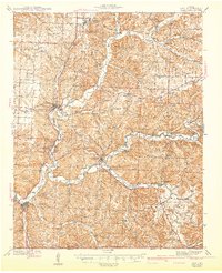
1943 Map of Noel
USGS Topo · Published 1943About this map
Indian Creek and the Elk River define the winding geography of McDonald County in the late 1930s, serving as the primary corridors for both travel and recreation. The Kansas City Southern Railway snakes through the valley, connecting settlements like Anderson and Noel while passing landmarks such as the Riverside Inn and the subterranean Bluff Dwellers Cave. The landscape is a patchwork of small upland prairies, including White Rock Prairie, and timbered ridges like Pleasant Ridge.
Find a feature on this map
83 named features on this map. Tap any name to fly to it.
Don’t see what you’re looking for? This feature index may not catch every label — zoom into the map to look around manually.
Map Details
Editions of this 1943 Noel Map
2 editions found

Other maps of this area

1899 · Fayetteville
USGS Topo · 1:125,000

1899 · Siloam Springs
USGS Topo · 1:125,000

1901 · Fayetteville
USGS Topo · 1:125,000

1903 · Siloam Springs
USGS Topo · 1:125,000

1904 · Siloam Springs
USGS Topo · 1:125,000

1904 · Fayetteville
USGS Topo · 1:125,000

1907 · Wyandotte
USGS Topo · 1:125,000

1909 · Wyandotte
USGS Topo · 1:125,000

1916 · Neosho
USGS Topo · 1:62,500

1940 · Noel
USGS Topo · 1:62,500