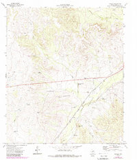
1971 Map of Noelke
USGS Topo · Published 1988About this map
The Mertzon Oil Field dominates this 1970s West Texas landscape, illustrating the industrial infrastructure of the Permian Basin. The terrain is defined by a dense network of energy assets, including a Refinery, multiple Gas Wells, and an extensive system of pipelines crossing the arid draws. The Atchison Topeka and Santa Fe railroad cuts a diagonal line through the valley of Spring Creek, providing the essential transportation link for the region's petroleum and ranching output.
Find a feature on this map
29 named features on this map. Tap any name to fly to it.
Don’t see what you’re looking for? This feature index may not catch every label — zoom into the map to look around manually.
Map Details
Editions of this 1971 Noelke Map
2 editions found
Other maps of this area

1895 · Sherwood
USGS Topo · 1:125,000

1920 · Barnhart
USGS Topo · 1:62,500

1921 · Ketchum Mountain
USGS Topo · 1:62,500

1922 · Barnhart
USGS Topo · 1:62,500

1923 · Ketchum Mountain
USGS Topo · 1:62,500

1954 · San Angelo
USGS Topo · 1:250,000

1958 · San Angelo
USGS Topo · 1:250,000

1965 · San Angelo
USGS Topo · 1:250,000

1971 · Noelke
USGS Topo · 1:24,000
1971 · Barnhart NE
USGS Topo · 1:24,000