
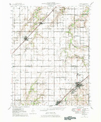
1946 Map of Nokomis
USGS Topo · Published 1965About this map
Nokomis and the neighboring coal-mining community of Coalton anchor the southeastern corner of this Central Illinois landscape, where the New York Central railroad provides a critical industrial corridor. The map reveals a dense agricultural grid defined by the boundaries of Bear Creek, Ricks, and Johnson townships, dotted with an exceptional number of one-room schoolhouses such as D'Arcy Sch and Sassafras Sch.
Find a feature on this map
80 named features on this map. Tap any name to fly to it.
Don’t see what you’re looking for? This feature index may not catch every label — zoom into the map to look around manually.
Map Details
Editions of this 1946 Nokomis Map
2 editions found
Other maps of this area

1915 · Mount Olive
USGS Topo · 1:62,500

1922 · Divernon
USGS Topo · 1:62,500

1923 · Taylorville
USGS Topo · 1:62,500

1923 · Raymond
USGS Topo · 1:62,500

1924 · Divernon
USGS Topo · 1:62,500

1925 · Taylorville
USGS Topo · 1:62,500

1925 · Raymond
USGS Topo · 1:62,500

1944 · Mount Olive
USGS Topo · 1:62,500

1944 · Ramsey
USGS Topo · 1:62,500

1946 · Ramsey
USGS Topo · 1:62,500