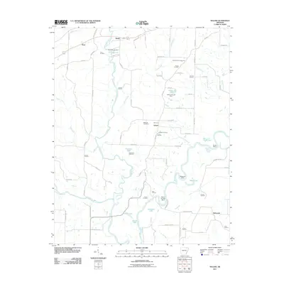
2011 Map of Noland
USGS Topo · Published 2011About this map
The Eleven Point River and the Black River converge in this part of Randolph County, creating a landscape defined by sharp river bends and oxbow lakes. Settlements such as Birdell, Noland, and Richwoods are scattered across the terrain, linked by a network of rural roads that navigate around the numerous water bodies. The confluence of several major waterways, including the Spring River and Julia Dean Creek, results in distinctive geographical features like Deadman Bend, Scotts Bend, and the curiously named Bull Pizzle Lake.
Find a feature on this map
86 named features on this map. Tap any name to fly to it.
Don’t see what you’re looking for? This feature index may not catch every label — zoom into the map to look around manually.
Map Details
Editions of this 2011 Noland Map
This is the sole edition of this map. No revisions or reprints were ever made.
Other maps of this area

1932 · Walnut Ridge
USGS Topo · 1:62,500

1934 · Powhatan
USGS Topo · 1:62,500

1935 · Powhatan
USGS Topo · 1:62,500

1935 · Reyno
USGS Topo · 1:62,500

1935 · Walnut Ridge
USGS Topo · 1:62,500

1957 · Poplar Bluff
USGS Topo · 1:250,000

1959 · Poplar Bluff
USGS Topo · 1:250,000

1960 · Poplar Bluff
USGS Topo · 1:250,000
1965 · Walnut Ridge
USGS Topo · 1:24,000
1965 · Manson
USGS Topo · 1:24,000