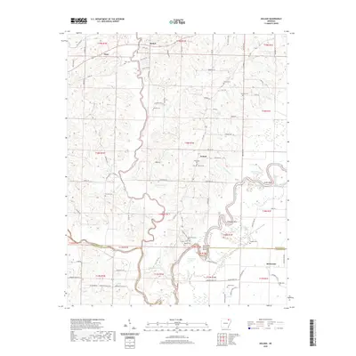
2020 Map of Noland
USGS Topo · Published 2020About this map
The Black River meanders sharply across this landscape, defining the rural geography of Noland and the surrounding borderlands of Randolph and Lawrence counties. This riverine environment is marked by distinct fluvial features such as Deadman Bend, Scotts Bend, and the aptly named Hole in the Wall Bend. Small, dispersed settlements like Birdell, Dunn, and Richwoods anchor the upland and bottomland areas, connected by a network of local roads including Old Union Rd and Kilo Vista Rd. For those tracing family histories, the map identifies numerous local burying grounds, such as Huffstedler Cem, Chesser Cem, and Throop Cem, which remain as persistent landmarks in a territory dominated by slow-moving water and seasonal wetlands. The proximity of Horseshoe Lake and Straight Lake reflects the dynamic nature of the river as it shifts through the Arkansas lowlands.
Find a feature on this map
96 named features on this map. Tap any name to fly to it.
Don’t see what you’re looking for? This feature index may not catch every label — zoom into the map to look around manually.
Map Details
Editions of this 2020 Noland Map
This is the sole edition of this map. No revisions or reprints were ever made.
Other maps of this area

1932 · Walnut Ridge
USGS Topo · 1:62,500

1934 · Powhatan
USGS Topo · 1:62,500

1935 · Powhatan
USGS Topo · 1:62,500

1935 · Reyno
USGS Topo · 1:62,500

1935 · Walnut Ridge
USGS Topo · 1:62,500

1957 · Poplar Bluff
USGS Topo · 1:250,000

1959 · Poplar Bluff
USGS Topo · 1:250,000

1960 · Poplar Bluff
USGS Topo · 1:250,000
1965 · Walnut Ridge
USGS Topo · 1:24,000
1965 · Manson
USGS Topo · 1:24,000