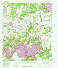
1958 Map of Nolanville
USGS Topo · Published 1975About this map
Nolanville serves as the central hub of this mid-century Bell County survey, situated just south of the Fort Hood Military Reservation boundary. The landscape is defined by its water systems and infrastructure, featuring the confluence of North Nolan Creek and South Nolan Creek. A significant transition is visible through purple revisions showing the formation of Stillhouse Hollow Lake and its control structure on the Lampasas River, reflecting the era's major hydrological engineering projects. The Atchison Topeka and Santa Fe railroad cuts a straight line through the center of the sheet, passing by rural developments like Nolan Valley and a local Trailer Park. Genealogists and local historians can locate smaller landmarks such as the Burris Cem and the Yarrell Well No 2 alongside terrain features like Commanche Gap and Dana Peak.
Find a feature on this map
24 named features on this map. Tap any name to fly to it.
Don’t see what you’re looking for? This feature index may not catch every label — zoom into the map to look around manually.
Map Details
Editions of this 1958 Nolanville Map
3 editions found
Other maps of this area

1885 · Taylor
USGS Topo · 1:125,000

1887 · Taylor
USGS Topo · 1:125,000

1892 · Temple
USGS Topo · 1:125,000

1893 · Georgetown
USGS Topo · 1:125,000

1894 · Gatesville
USGS Topo · 1:125,000

1894 · Taylor
USGS Topo · 1:125,000

1924 · Gatesville 4-d
USGS Topo · 1:48,000

1924 · Gatesville 4-a
USGS Topo · 1:48,000

1924 · Temple 3-C
USGS Topo · 1:48,000

1924 · Temple 3-B
USGS Topo · 1:48,000