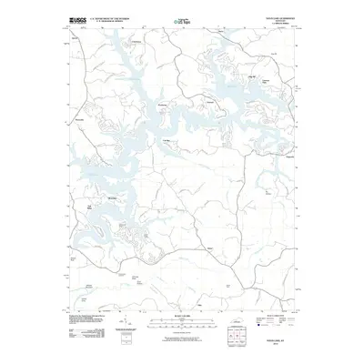
2010 Map of Nolin Lake
USGS Topo · Published 2010About this map
Nolin Lake dominates this central Kentucky landscape, its irregular shoreline reaching into numerous hollows and creek beds. The map documents a blend of recreation and rural settlement, with shoreline developments like Linwood Park and Wax Recreation Area contrasting with the more traditional communities of Straw and Ollie. This 2010 survey shows how modern infrastructure, such as the bridges at Moutadier, has connected previously isolated ridges and peninsulas.
Find a feature on this map
67 named features on this map. Tap any name to fly to it.
Don’t see what you’re looking for? This feature index may not catch every label — zoom into the map to look around manually.
Map Details
Editions of this 2010 Nolin Lake Map
This is the sole edition of this map. No revisions or reprints were ever made.
Other maps of this area

1922 · Leitchfield
USGS Topo · 1:48,000

1922 · Brownsville
USGS Topo · 1:62,500

1922 · Mammoth Cave
USGS Topo · 1:62,500

1923 · Mammoth Cave
USGS Topo · 1:62,500

1923 · Brownsville
USGS Topo · 1:62,500

1925 · Cub Run
USGS Topo · 1:62,500

1925 · Leitchfield
USGS Topo · 1:62,500

1953 · Bee Spring
USGS Topo · 1:24,000

1954 · Evansville
USGS Topo · 1:250,000
1954 · Dickeys Mills
USGS Topo · 1:24,000