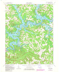
1966 Map of Nolin Lake
USGS Topo · Published 1982About this map
Nolin River Lake dominates this landscape where the borders of Grayson and Edmonson counties meet, its dendritic fingers reaching deep into the hollows of the Pennyroyal Plateau. This 1966 revision shows the area as the newly created reservoir transformed the valley, submerging older crossings while creating numerous public access points like the Dickeys Mill Recreation Area and Moutardier Recreation Area. To the south, the map captures a portion of Mammoth Cave National Park, where the terrain rises toward Whistle Mtn and Oak Ridge. Small rural communities and landmarks like Demunbruns Store, Union Light Ch, and the Lincoln Sch provide essential geographic markers for genealogists tracing family roots near the Nolin River. The rugged topography is further detailed by named features such as Chimney Stack and the historic Wilderness Road winding through the southern hills.
Find a feature on this map
45 named features on this map. Tap any name to fly to it.
Don’t see what you’re looking for? This feature index may not catch every label — zoom into the map to look around manually.
Map Details
Editions of this 1966 Nolin Lake Map
3 editions found
Other maps of this area

1922 · Leitchfield
USGS Topo · 1:48,000

1922 · Brownsville
USGS Topo · 1:62,500

1922 · Mammoth Cave
USGS Topo · 1:62,500

1923 · Mammoth Cave
USGS Topo · 1:62,500

1923 · Brownsville
USGS Topo · 1:62,500

1925 · Cub Run
USGS Topo · 1:62,500

1925 · Leitchfield
USGS Topo · 1:62,500

1953 · Bee Spring
USGS Topo · 1:24,000

1954 · Evansville
USGS Topo · 1:250,000
1954 · Dickeys Mills
USGS Topo · 1:24,000