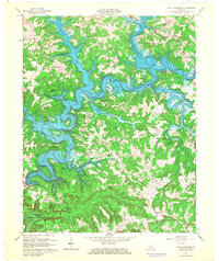
1966 Map of Nolin Reservoir
USGS Topo · Published 1968About this map
The winding waters of Nolin Reservoir dominate this mid-century landscape, carving a deep blue path through the timbered hills of Edmonson and Grayson counties. This 1966 survey shows the reservoir at its normal pool elevation of 515 feet, creating a labyrinth of coves and branches such as Conoloway Creek and Long Fall Creek. The topography reveals the dramatic transition from the ridge-top settlements of Anneta and Iberia down to the shoreline developments like Nolin Lake Estates and Linwood Park.
Find a feature on this map
47 named features on this map. Tap any name to fly to it.
Don’t see what you’re looking for? This feature index may not catch every label — zoom into the map to look around manually.
Map Details
Editions of this 1966 Nolin Reservoir Map
3 editions found
Other maps of this area

1922 · Leitchfield
USGS Topo · 1:48,000

1922 · Brownsville
USGS Topo · 1:62,500

1922 · Mammoth Cave
USGS Topo · 1:62,500

1923 · Mammoth Cave
USGS Topo · 1:62,500

1923 · Brownsville
USGS Topo · 1:62,500

1925 · Cub Run
USGS Topo · 1:62,500

1925 · Leitchfield
USGS Topo · 1:62,500

1953 · Bee Spring
USGS Topo · 1:24,000

1954 · Evansville
USGS Topo · 1:250,000
1954 · Dickeys Mills
USGS Topo · 1:24,000