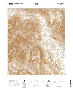
2017 Map of Nome C-1 NE
USGS Topo · Published 2017About this map
The Seward Peninsula interior is defined here by a series of steep drainages and prospector-named gulches east of the Nome River. The Kougarok Road (Nome-Taylor Highway) cuts through the northwestern corner of the quadrangle, serving as the primary corridor into this mineral-rich landscape. Prominent elevations like Osborn Dome overlook a network of gold-rush era waterways, including Gold Run, Nugget Gulch, and New Eldorado Cr. These names reflect the intense legacy of placer mining that shaped the region's geography. Toward the east, the terrain descends into the wetlands and braided channels of the Flambeau River, where smaller tributaries such as Tee-Pee Cr and Hazel Cr join the main flow. This survey documents the persistent landscape of the Alaska mining country, where old trails and creek names preserve the history of 20th-century exploration.
Find a feature on this map
43 named features on this map. Tap any name to fly to it.
Don’t see what you’re looking for? This feature index may not catch every label — zoom into the map to look around manually.
Map Details
Editions of this 2017 Nome C-1 NE Map
This is the sole edition of this map. No revisions or reprints were ever made.
Other maps of this area

1950 · Nome
USGS Topo · 1:250,000

1950 · Solomon C-6
USGS Topo · 1:63,360

1950 · Solomon
USGS Topo · 1:250,000

1950 · Solomon D-6
USGS Topo · 1:63,360

1950 · Nome D-1
USGS Topo · 1:63,360

1950 · Nome C-1
USGS Topo · 1:63,360

1951 · Nome
USGS Topo · 1:250,000

1951 · Solomon
USGS Topo · 1:250,000

1957 · Nome
USGS Topo · 1:250,000
1972 · Nome D-1
USGS Topo · 1:63,360