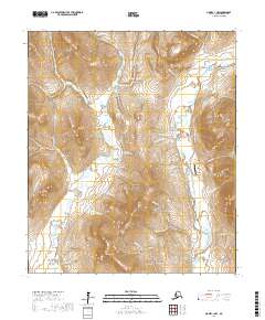
2017 Map of Nome C-1 NW
USGS Topo · Published 2017About this map
Mt Brynteson and Engstrom Mtn loom over a landscape defined by the legacies of the Seward Peninsula gold rush. The terrain is deeply incised by a dense network of watercourses, including the Nome River and the Snake River, which are flanked by dozens of gulches and canyons. This 2017 survey shows the enduring transportation corridors that connect the interior to the coast, specifically the Kougarok Road/Nome-Taylor Highway and Glacier Creek Road. Aviation infrastructure is represented by the Basin Creek Airport, situated near the confluence of Barr Cr and the main river. Numerous smaller creeks such as Goldbottom Cr and Last Chance Cr flow through the gulches, marking the locations of historical prospecting and hydraulic mining activity in the hills north of Nome.
Find a feature on this map
68 named features on this map. Tap any name to fly to it.
Don’t see what you’re looking for? This feature index may not catch every label — zoom into the map to look around manually.
Map Details
Editions of this 2017 Nome C-1 NW Map
This is the sole edition of this map. No revisions or reprints were ever made.
Other maps of this area

1950 · Nome D-2
USGS Topo · 1:63,360

1950 · Nome
USGS Topo · 1:250,000

1950 · Nome D-1
USGS Topo · 1:63,360

1950 · Nome C-2
USGS Topo · 1:63,360

1950 · Nome C-1
USGS Topo · 1:63,360

1951 · Nome
USGS Topo · 1:250,000

1957 · Nome
USGS Topo · 1:250,000
1972 · Nome D-1
USGS Topo · 1:63,360
2017 · Nome D-1 SW
USGS Topo · 1:25,000
2017 · Nome C-1 SW
USGS Topo · 1:25,000