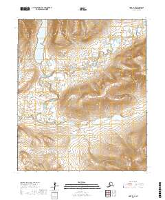
2017 Map of Nome D-2 SE
USGS Topo · Published 2017About this map
Glacial Lake sits at the northern end of this interior landscape, feeding a complex drainage system that includes Sinuk and its many tributaries. The area is defined by its dramatic elevation changes and a dense network of mountain streams. In the south, the Stewart River cuts through the terrain, joined by smaller waterways such as Durrant Cr and Jessie Cr. This map documents a largely unpopulated wilderness in the Seward Peninsula, where the landscape is shaped primarily by these watercourses and the surrounding ridges. The survey illustrates the hydrologic connection between Moose Cr and Mosie Cr as they flow through the southern townships, providing a detailed record of the region's topography and drainage patterns at the time of the 2017 survey.
Find a feature on this map
12 named features on this map. Tap any name to fly to it.
Don’t see what you’re looking for? This feature index may not catch every label — zoom into the map to look around manually.
Map Details
Editions of this 2017 Nome D-2 SE Map
This is the sole edition of this map. No revisions or reprints were ever made.
Other maps of this area

1950 · Nome D-2
USGS Topo · 1:63,360

1950 · Nome
USGS Topo · 1:250,000

1950 · Nome D-1
USGS Topo · 1:63,360

1950 · Nome C-2
USGS Topo · 1:63,360

1950 · Nome C-1
USGS Topo · 1:63,360

1951 · Nome
USGS Topo · 1:250,000

1957 · Nome
USGS Topo · 1:250,000
1972 · Nome D-1
USGS Topo · 1:63,360
2017 · Nome D-1 NW
USGS Topo · 1:25,000
2017 · Nome D-1 SW
USGS Topo · 1:25,000