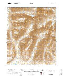
2017 Map of Nome D-1 NW
USGS Topo · Published 2017About this map
Kigluaik Mountains dominate this portion of the Seward Peninsula, forming a high-relief divide between major drainages north of Nome. High peaks such as Mt Osborn and Tiġaraha Mtn overlook a glaciated landscape defined by sharp ridges and significant water sources like Crater Lake. The drainage network is complex, with the Cobblestone River flowing to the west while the N Fork Grand Central River and W Fork Grand Central River converge in the northeast. Access through this challenging terrain is marked by Mosquito Pass, a critical topographic notch between the Windy Cr and Sinuk valleys. The map illustrates a wilderness landscape where name density is highest along watercourses like Thompson Cr and Buffalo Cr, which serve as primary landmarks for navigation and resource exploration in the region.
Find a feature on this map
19 named features on this map. Tap any name to fly to it.
Don’t see what you’re looking for? This feature index may not catch every label — zoom into the map to look around manually.
Map Details
Editions of this 2017 Nome D-1 NW Map
This is the sole edition of this map. No revisions or reprints were ever made.
Other maps of this area

1950 · Nome D-2
USGS Topo · 1:63,360

1950 · Nome
USGS Topo · 1:250,000

1950 · Teller
USGS Topo · 1:250,000

1950 · Teller A-2
USGS Topo · 1:63,360

1950 · Nome D-1
USGS Topo · 1:63,360

1950 · Teller A-1
USGS Topo · 1:63,360

1951 · Nome
USGS Topo · 1:250,000

1951 · Teller
USGS Topo · 1:250,000

1957 · Nome
USGS Topo · 1:250,000

1957 · Teller
USGS Topo · 1:250,000