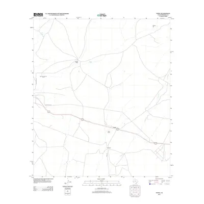
2012 Map of Nopal
USGS Topo · Published 2012About this map
Nopal and the nearby Nopal Ranch anchor this West Texas landscape in Presidio County, where the high desert terrain is defined by an intricate network of seasonal drainages. Significant natural water-collection points like Catto Tank and W-Bar Tank highlight the necessity of water management in this arid environment, supporting the ranching operations that characterize the region. The map reveals a land of open spaces marked by prominent features such as Orphan Hill and the converging paths of Ponder Draw, Short Draw, and the extensive Long Draw. Cultural developments include the Marfa Municipal Golf Course in the western section, while the local transportation network is traced via Antelope Hills Rd and Nopal Rd, providing a clear view of the rural infrastructure during the early 21st century.
Find a feature on this map
12 named features on this map. Tap any name to fly to it.
Don’t see what you’re looking for? This feature index may not catch every label — zoom into the map to look around manually.
Map Details
Editions of this 2012 Nopal Map
This is the sole edition of this map. No revisions or reprints were ever made.
Other maps of this area

1895 · Marfa
USGS Topo · 1:125,000

1895 · Alpine
USGS Topo · 1:125,000

1954 · Fort Stockton
USGS Topo · 1:250,000

1958 · Fort Stockton
USGS Topo · 1:250,000

1959 · Marfa
USGS Topo · 1:250,000

1965 · Marfa
USGS Topo · 1:250,000

1972 · Paisano
USGS Topo · 1:24,000

1972 · Mitre Peak
USGS Topo · 1:24,000

1972 · Nopal
USGS Topo · 1:24,000
1972 · Mano Prieto Mountain
USGS Topo · 1:24,000