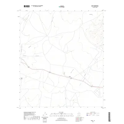
2019 Map of Nopal
USGS Topo · Published 2019About this map
Nopal sits at the intersection of local routes in this arid section of Presidio County, where the landscape is defined by a sophisticated network of ephemeral drainage channels. Several named water features, including Cuervo Draw, Ponder Draw, and Greenlee Draw, illustrate the region's reliance on intermittent runoff and localized water management systems like W-Bar Tank and Catto Tank. The terrain rises toward the east, punctuated by the distinct elevation of Orphan Hill, while the MacGuire Ranch Airport provides a localized hub for ranching operations and air travel. This 2019 survey documents the modern ranching infrastructure and road network, featuring Antelope Hills Rd and Donnell Rd, which weave through the high desert environment to connect isolated homesteads and grazing lands.
Find a feature on this map
17 named features on this map. Tap any name to fly to it.
Don’t see what you’re looking for? This feature index may not catch every label — zoom into the map to look around manually.
Map Details
Editions of this 2019 Nopal Map
This is the sole edition of this map. No revisions or reprints were ever made.
Other maps of this area

1895 · Marfa
USGS Topo · 1:125,000

1895 · Alpine
USGS Topo · 1:125,000

1954 · Fort Stockton
USGS Topo · 1:250,000

1958 · Fort Stockton
USGS Topo · 1:250,000

1959 · Marfa
USGS Topo · 1:250,000

1965 · Marfa
USGS Topo · 1:250,000

1972 · Paisano
USGS Topo · 1:24,000

1972 · Mitre Peak
USGS Topo · 1:24,000

1972 · Nopal
USGS Topo · 1:24,000
1972 · Mano Prieto Mountain
USGS Topo · 1:24,000