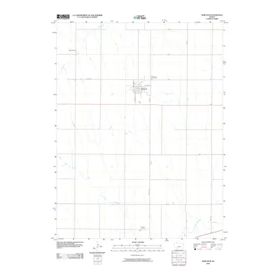
2009 Map of Norcatur
USGS Topo · Published 2009About this map
Norcatur sits at the intersection of local routes in this pocket of Decatur County, where the grid of the High Plains is broken only by the winding paths of seasonal waterways. The town plan is clearly defined by streets such as N Dewitt Ave and E Olathe St, which provide a glimpse into the organized growth of this rural center. Surrounding the town, the land is marked by long-standing landmarks like the Stapp Ranch and the Norcatur Cemetery to the northeast. To the south, the terrain descends toward Prairie Dog Creek, with Clayton Cemetery marking the southern boundary of the quadrangle. The map captures the agricultural endurance of the region, where roads like Co Rd 507 and Rd W-15 link isolated homesteads across a landscape drained by Plum Creek and Long Branch.
Find a feature on this map
23 named features on this map. Tap any name to fly to it.
Don’t see what you’re looking for? This feature index may not catch every label — zoom into the map to look around manually.
Map Details
Editions of this 2009 Norcatur Map
This is the sole edition of this map. No revisions or reprints were ever made.
Other maps of this area

1951 · Norcatur
USGS Topo · 1:62,500

1951 · Kanona
USGS Topo · 1:62,500

1954 · Goodland
USGS Topo · 1:250,000

1956 · Goodland
USGS Topo · 1:250,000

1957 · Goodland
USGS Topo · 1:250,000

1965 · Kanona SE
USGS Topo · 1:24,000
1965 · Lyle
USGS Topo · 1:24,000
1965 · Kanona NE
USGS Topo · 1:24,000
1965 · Devizes
USGS Topo · 1:24,000

1978 · Clayton
USGS Topo · 1:24,000