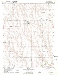
1978 Map of Norcatur
USGS Topo · Published 1979About this map
Norcatur serves as the central hub of this High Plains landscape, situated along the Burlington Northern line near the border of Decatur and Norton Counties. The town plan is clearly defined, featuring a concentrated residential grid and a prominent WT (water tower) near the railway tracks. This 1970s survey illustrates a region shaped by agricultural drainage and rail transport, with the land divided into the townships of Lincoln, Rockwell, Garfield, and Clayton.
Find a feature on this map
17 named features on this map. Tap any name to fly to it.
Don’t see what you’re looking for? This feature index may not catch every label — zoom into the map to look around manually.
Map Details
Editions of this 1978 Norcatur Map
This is the sole edition of this map. No revisions or reprints were ever made.
Other maps of this area

1951 · Norcatur
USGS Topo · 1:62,500

1951 · Kanona
USGS Topo · 1:62,500

1954 · Goodland
USGS Topo · 1:250,000

1956 · Goodland
USGS Topo · 1:250,000

1957 · Goodland
USGS Topo · 1:250,000

1965 · Kanona SE
USGS Topo · 1:24,000
1965 · Lyle
USGS Topo · 1:24,000
1965 · Kanona NE
USGS Topo · 1:24,000
1965 · Devizes
USGS Topo · 1:24,000

1978 · Clayton
USGS Topo · 1:24,000