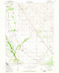
1951 Map of Nord
USGS Topo · Published 1963About this map
Nord stands as a central settlement in this agricultural landscape of the early 1950s, situated along the Southern Pacific railroad line. The map reveals a transition from the lower alluvial plains of the Bosque Joaquin to the dissected slopes of the southern Sacramento Valley. Notable local infrastructure includes the Gianella Bridge and the Pumping Sta near the Butte Co Glenn Co line, illustrating the region's reliance on water management for irrigation. Small rural hubs like Cana and Anita are connected by a network of named tracks such as Wilson Landing Road and Keefer Lane. Genealogists may find interest in the Pine Creek Cem and the Shasta Union Sch, which served the scattered farming families of the Arroyo Chico grant lands. The Mt Diablo Meridian provides a primary surveying anchor across the eastern half of the quadrangle.
Find a feature on this map
28 named features on this map. Tap any name to fly to it.
Don’t see what you’re looking for? This feature index may not catch every label — zoom into the map to look around manually.
Map Details
Editions of this 1951 Nord Map
4 editions found
Other maps of this area

1891 · Chico
USGS Topo · 1:125,000

1893 · Chico
USGS Topo · 1:125,000

1895 · Chico
USGS Topo · 1:125,000

1904 · Vina
USGS Topo · 1:62,500

1906 · Willows
USGS Topo · 1:62,500

1912 · Durham
USGS Topo · 1:31,680

1912 · Nord
USGS Topo · 1:31,680

1912 · Chico Landing
USGS Topo · 1:31,680

1912 · Keefers
USGS Topo · 1:31,680

1912 · Singer Creek
USGS Topo · 1:31,680