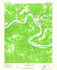
1966 Map of Norfork
USGS Topo · Published 1967About this map
The White River carves a deep, serpentine path through the Ozark landscape of Baxter County, defining the geography of this mid-1960s survey. The Missouri Pacific railroad tracks follow the river's tight bends, serving riverside communities like Norfork and Arkana Station. This era shows a landscape transitioning from traditional river crossings to modern infrastructure, where historic transport points such as Shipps Ferry and Martins Ferry remain notable landmarks alongside the modern gaging station.
Find a feature on this map
67 named features on this map. Tap any name to fly to it.
Don’t see what you’re looking for? This feature index may not catch every label — zoom into the map to look around manually.
Map Details
Editions of this 1966 Norfork Map
2 editions found
Other maps of this area

1890 · Mountain Home
USGS Topo · 1:125,000

1891 · Mountain Home
USGS Topo · 1:125,000

1894 · Mountain Home
USGS Topo · 1:125,000

1945 · Harrison
USGS Topo · 1:250,000

1949 · Harrison
USGS Topo · 1:250,000

1954 · Harrison
USGS Topo · 1:250,000

1958 · Harrison
USGS Topo · 1:250,000

1964 · Harrison
USGS Topo · 1:250,000
1964 · Calico Rock
USGS Topo · 1:24,000
1964 · Norfork Dam South
USGS Topo · 1:24,000