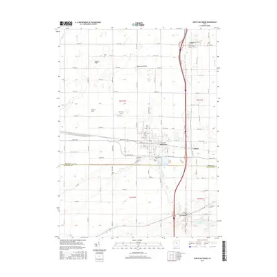
2016 Map of North Baltimore
USGS Topo · Published 2016About this map
The village of North Baltimore serves as a central hub in this western Ohio landscape, where the flat agricultural plains of Wood and Hancock counties meet. This 2016 survey highlights a well-organized grid of township and county roads, reflecting the region's long-standing land survey system. The Interstate 75 corridor bisects the area, running north-south past the smaller settlements of Cygnet and Galatea, while Hammansburg and Van Buren anchor the northern and southern reaches.
Find a feature on this map
92 named features on this map. Tap any name to fly to it.
Don’t see what you’re looking for? This feature index may not catch every label — zoom into the map to look around manually.
Map Details
Editions of this 2016 North Baltimore Map
This is the sole edition of this map. No revisions or reprints were ever made.
Other maps of this area

1901 · Bowling Green
USGS Topo · 1:62,500

1903 · Bowling Green
USGS Topo · 1:62,500

1903 · Findlay
USGS Topo · 1:62,500

1909 · Mc Clure
USGS Topo · 1:62,500

1956 · Toledo
USGS Topo · 1:250,000

1958 · Jerry City
USGS Topo · 1:24,000

1958 · Bowling Green South
USGS Topo · 1:24,000

1960 · Bloomdale
USGS Topo · 1:24,000

1960 · North Baltimore
USGS Topo · 1:24,000
1960 · Weston
USGS Topo · 1:24,000