
1958 Map of Jerry City
USGS Topo · Published 1960About this map
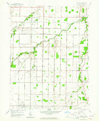
Jerry City and the surrounding townships of Center, Freedom, and Portage are defined by a sophisticated network of oil production and drainage in this mid-century survey. The landscape is punctuated by dozens of Oil Wells, particularly concentrated west of Six Points and south of Mermill Road. This industrial presence coexists with long-established rural institutions like the Portage Sch, Hope American Ch, and Mt Zion Ch. The hydrology of the region is dominated by the branching arms of the Portage River, including the Middle Branch Portage River and South Branch Portage River, which meander through Wood County's agricultural fields. In the northern reaches, the Grand Army of the Republic Highway serves as a major transit artery, passing near the settlement of New Rochester.
Find a feature on this map
46 named features on this map. Tap any name to fly to it.
Don’t see what you’re looking for? This feature index may not catch every label — zoom into the map to look around manually.
Map Details
Editions of this 1958 Jerry City Map
2 editions found
Other maps of this area

1901 · Fostoria
USGS Topo · 1:62,500

1901 · Bowling Green
USGS Topo · 1:62,500

1901 · Elmore
USGS Topo · 1:62,500

1903 · Bowling Green
USGS Topo · 1:62,500

1903 · Fostoria
USGS Topo · 1:62,500

1903 · Findlay
USGS Topo · 1:62,500

1903 · Elmore
USGS Topo · 1:62,500
1938 · Tontogany
USGS Topo · 1:31,680
1952 · Tontogany
USGS Topo · 1:24,000

1956 · Toledo
USGS Topo · 1:250,000