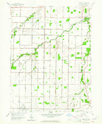
1958 Map of Jerry City
USGS Topo · Published 1964About this map
Jerry City sits at the heart of this mid-century Wood County landscape, where the agricultural grid is defined by the complex branching of the North Branch, Middle Branch, and South Branch Portage River. The map reveals a robust rural infrastructure of the 1950s, characterized by numerous Oil Wells scattered across townships like Portage and Montgomery. These small-scale extraction points punctuate the fields between established community centers such as New Rochester and Six Points. Local life is anchored by country institutions including Portage Sch, the Jerry City Cem, and several named congregations like Hope American Ch and Mt Zion Ch. The dense network of section-line roads, such as Mermill Road and Greensburg Pike, facilitates movement across this hydraulic landscape where Bull Creek and Cuckle Creek feed the larger Portage system.
Find a feature on this map
57 named features on this map. Tap any name to fly to it.
Don’t see what you’re looking for? This feature index may not catch every label — zoom into the map to look around manually.
Map Details
Editions of this 1958 Jerry City Map
2 editions found

Other maps of this area

1901 · Fostoria
USGS Topo · 1:62,500

1901 · Bowling Green
USGS Topo · 1:62,500

1901 · Elmore
USGS Topo · 1:62,500

1903 · Bowling Green
USGS Topo · 1:62,500

1903 · Fostoria
USGS Topo · 1:62,500

1903 · Findlay
USGS Topo · 1:62,500

1903 · Elmore
USGS Topo · 1:62,500
1938 · Tontogany
USGS Topo · 1:31,680
1952 · Tontogany
USGS Topo · 1:24,000

1956 · Toledo
USGS Topo · 1:250,000