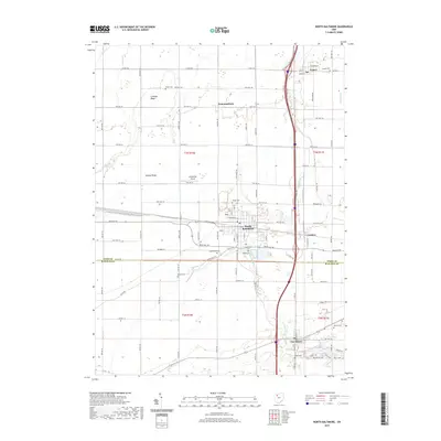
2019 Map of North Baltimore
USGS Topo · Published 2019About this map
North Baltimore serves as the central hub of this region, where the intersection of Deshler Rd and S Dixie Hwy marks a long-standing transit corridor near the border of Wood Co and Hancock Co. The landscape is defined by its agricultural layout and numerous family-named landmarks like Callahan Ridge and Howard Ridge, reflecting a deep-rooted history of land ownership. In the northern reaches, the small settlement of Cygnet sits alongside Needles Cr, while the crossroads of Hammansburg and Galatea provide historical reference points for local researchers. Genealogists will find a significant concentration of burial sites, including Maplewood Cem, Fayler Cem, and Radar Cem, scattered across the township lines. The southern portion of the map transitions toward Van Buren, featuring local recreation and nature paths such as the Blue Trail, White Trail, and Red Trail near Cedar Lake.
Find a feature on this map
58 named features on this map. Tap any name to fly to it.
Don’t see what you’re looking for? This feature index may not catch every label — zoom into the map to look around manually.
Map Details
Editions of this 2019 North Baltimore Map
This is the sole edition of this map. No revisions or reprints were ever made.
Other maps of this area

1901 · Bowling Green
USGS Topo · 1:62,500

1903 · Bowling Green
USGS Topo · 1:62,500

1903 · Findlay
USGS Topo · 1:62,500

1909 · Mc Clure
USGS Topo · 1:62,500

1956 · Toledo
USGS Topo · 1:250,000

1958 · Jerry City
USGS Topo · 1:24,000

1958 · Bowling Green South
USGS Topo · 1:24,000

1960 · Bloomdale
USGS Topo · 1:24,000

1960 · North Baltimore
USGS Topo · 1:24,000
1960 · Weston
USGS Topo · 1:24,000