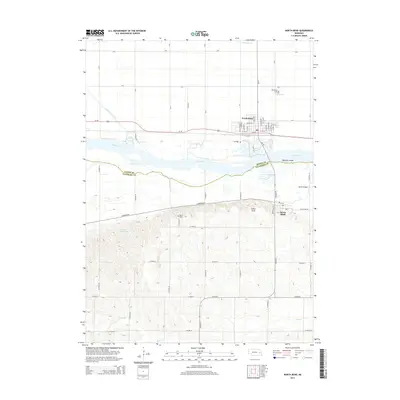
2014 Map of North Bend
USGS Topo · Published 2014About this map
The Platte River corridor separates Dodge and Saunders counties, defining the geography of this eastern Nebraska landscape. North Bend sits as a primary transit hub along the northern bank, where Us-30 and a grid of local streets like W 10th St and E 7th St meet. To the south, across the braided channels and Bignells Island, the terrain shifts toward the community of Morse Bluff.
Find a feature on this map
30 named features on this map. Tap any name to fly to it.
Don’t see what you’re looking for? This feature index may not catch every label — zoom into the map to look around manually.
Map Details
Editions of this 2014 North Bend Map
This is the sole edition of this map. No revisions or reprints were ever made.
Other maps of this area

1899 · Wahoo
USGS Topo · 1:125,000

1955 · Fremont
USGS Topo · 1:250,000

1957 · Fremont
USGS Topo · 1:250,000

1958 · Fremont
USGS Topo · 1:250,000

1966 · Scribner SW
USGS Topo · 1:24,000

1966 · Webster
USGS Topo · 1:24,000

1966 · Dodge SW
USGS Topo · 1:24,000

1968 · Bruno
USGS Topo · 1:24,000
1968 · Malmo NW
USGS Topo · 1:24,000
1968 · North Bend
USGS Topo · 1:24,000